

Haya & family
ICELAND ADVENTURE

August 11 : West of Iceland
Kolugljúfur Canyon
Kolufossar Waterfall
Hvítserkur
Hraunsnef Country Hotel (Restaurant)
Accommodations : Hraundalur
Hvítserkur located on Vatnsnes peninsula in North-West Iceland, a 15-meter tall monolith or sea-stack, an eroded volcanic dyke. It looks like an animal of some sort, an elephant or a rhino; or even a dinosaur drinking. It is half-white from their guano, thus the name Hvítserkur; "hvít-" = white and "-serkur" = a long shirt.
Kolugljúfur Canyon is a dramatic gorge in North Iceland, carved by the Víðidalsá River. At its heart lies Kolufossar, a series of powerful waterfalls plunging into the canyon’s depths.
Named after the legendary giantess Kola, the site combines natural beauty with Icelandic folklore. A small bridge offers great views of the falls, making it a perfect quick stop for nature lovers and photographers.
Driving Distances
Akureyri → Kolugljúfur Canyon / Kolufossar Waterfall
~2 hours 20 minutes | ~183 km
Kolugljúfur Canyon → Hvítserkur
~40 minutes | ~30 km
Hvítserkur → Hraunsnef Country Hotel (Restaurant)
~2 hours | ~155 km
Hraunsnef Country Hotel → Hraundalur
~1 hours 5 minutes | ~64 km

August 12 : Snæfellsnes peninsula
Kirkjufell Mountain
Lóndrangar Cliffs
Village of Arnarstapi
Miðgjá Stone Bridge
Ytri Tunga Seal beach
Accommodations : Hraundalur
Kirkjufell, or 'Church Mountain', is a distinctly shaped peak found on the north shore of Iceland’s Snæfellsnes Peninsula. It is often called ‘the most photographed mountain in Iceland’ due to its dramatic formation and perfect coastal location.
The Búðakirkja Church is a small wooden church erected on the southern shore of the Snæfellsnes Peninsula – where road 54 turns from the sea towards the mountains. It sits as a strong colour contrast against the backdrop of the Snæfellsjökull glacier, highlighted by its colour on its white vestry, and this makes it the most photographed church in Iceland.
Driving Distances
Hraundalur → Kirkjufell Mountain
~1 hour 50 minutes | ~145 km
Kirkjufell → Lóndrangar Cliffs
~1 hour 15 minutes | ~85 km
Lóndrangar → Arnarstapi Village
~10 minutes | ~8 km
Arnarstapi → Miðgjá Stone Bridge
~5 minutes | ~2 km
Miðgjá → Ytri Tunga Seal Beach
~35 minutes | ~35 km
Ytri Tunga → Hraundalur
~57 minutes | ~82 km
August 15 : Glacier Lagoon
Jökulsárlón Glacier Lagoon
Boat ride of the Lagoon
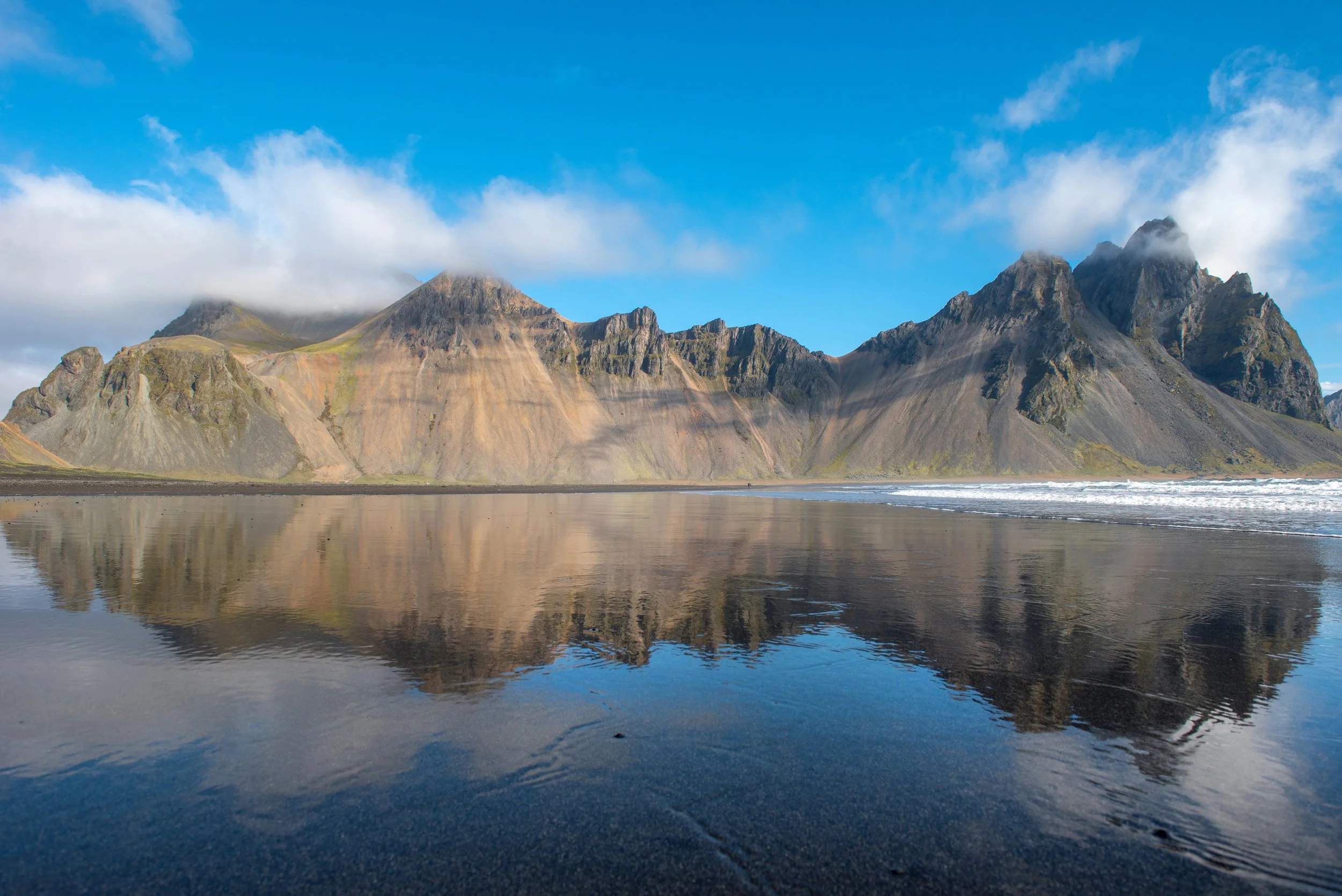
Vestrahorn
Viking Village
The Diamond Beach
Accommodations : Hrifunes Nature Park
We’ll dedicate most of the day to exploring the glacier—an unforgettable experience that blends adventure, discovery, and natural beauty. As we make our way across the ice, you'll have the opportunity to learn about the glacier’s unique features, its formation, and its role in Iceland’s dynamic landscape. Throughout the journey, we’ll pause for plenty of photo opportunities, capturing the striking contrasts of blue ice, deep crevasses, and sweeping mountain views. At the glacier’s summit or another scenic spot, we’ll take time to enjoy a packed lunch surrounded by breathtaking vistas, before beginning our hike back down.
Driving Distances
Hrifunes Nature Park → Jökulsárlón Glacier Lagoon
Distance: ~135 km
Driving Time: ~1 hr 45 min
Jökulsárlón → Vestrahorn (Stokksnes)
Distance: ~78 km
Driving Time: ~1 hr
Vestrahorn → Diamond Beach
Distance: ~79 km
Driving Time: ~1 hr
Diamond Beach → Hrifunes Nature Park
Distance: ~135 km
Driving Time: ~1 hr 45 min
August 16 : The south coast
Buggy Tour (booked for 13:00)
Reynisfjara Black Sand Beach
Seljalandsfoss Waterfall
Gljúfrabúi (The Cave Waterfall)
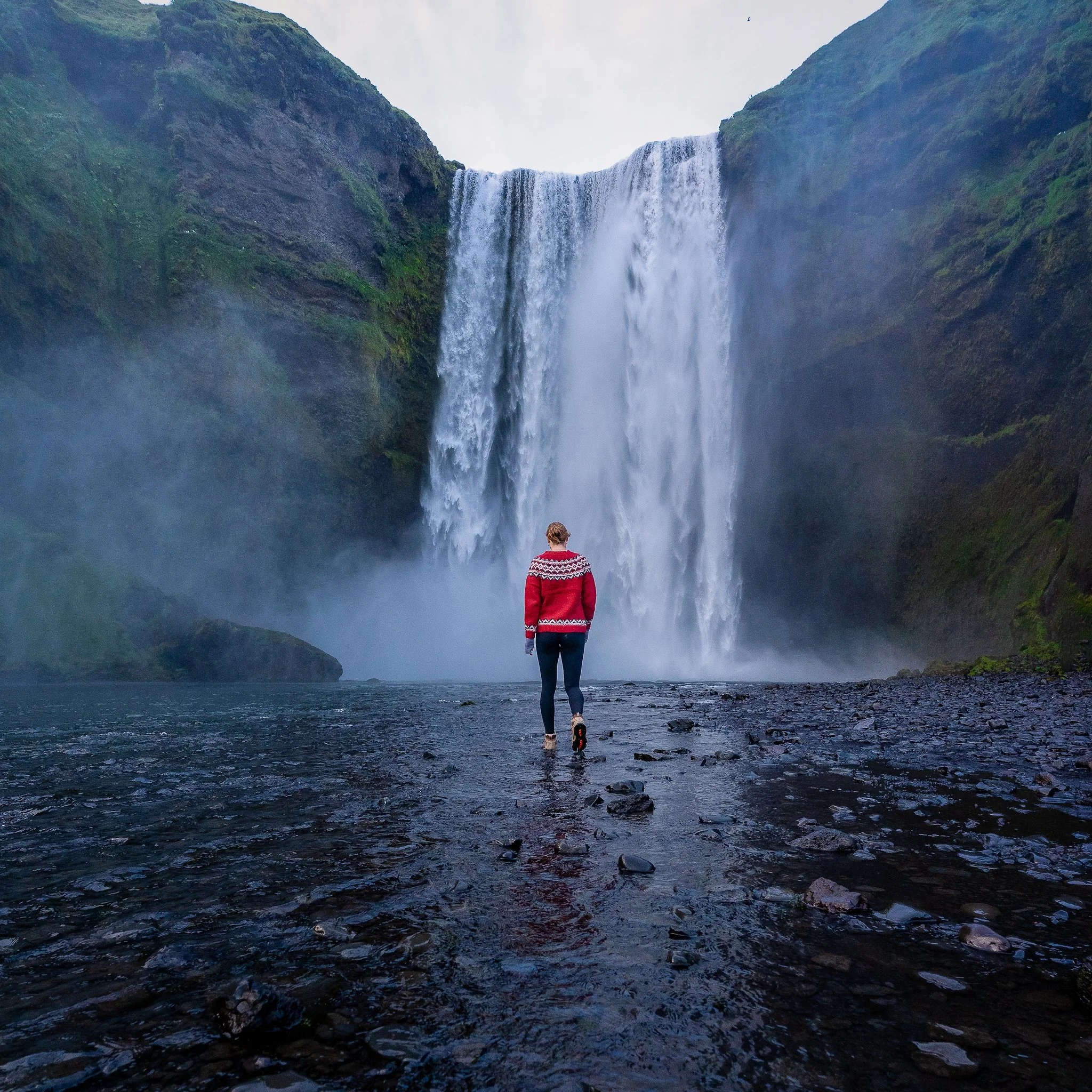
Skógafoss Waterfall
Accommodations : Hrifunes Nature Park
The South Coast is a must for amazing sceneries. You can expect to discover many of Iceland’s best features including black sand beaches, vast lava fields, known and hidden waterfalls and much more.
Driving Distances
Hrifunes Nature Park → Reynisfjara Black Sand Beach
Distance: ~55 km
Driving Time: ~45 min
Reynisfjara → Skógafoss Waterfall
Distance: ~34 km
Driving Time: ~30 min
Skógafoss → DC-3 Plane Wreck Parking Lot
Distance: ~11 km
Driving Time: ~10 min
+ Hike to wreck: ~4 km one way (~45–60 min each way)
DC-3 Plane Wreck Parking → Seljalandsfoss
Distance: ~26 km
Driving Time: ~20 min
Seljalandsfoss → Gljúfrabúi (just next door)
Distance: ~0.5 km
Driving Time: ~2 min or walkable
Gljúfrabúi → Hrifunes Nature Park
Distance: ~85 km
Driving Time: ~1 hr 10 min